Loop Head An Bord Pleanála Application
Consultation has concluded
1.0 Introduction - Loop Head Lighthouse, the proposed development to upgrade and provide enhanced visitor experience facilities
 Loop Head, Kilbaha, Co. Clare
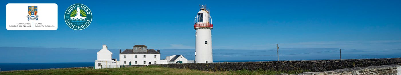
Loop Head Lighthouse is steeped in history and is rich in maritime heritage with its origins dating back to the 1670s. Located at the mouth of Shannon Estuary, the existing tower style lighthouse was constructed in 1854 and was operated and maintained by a keeper who lived within the lighthouse compound. In January 1991, the lighthouse was converted to automatic operation, and today is monitored by the Commissioner of Irish Lights.
By the time of the early 19th century Ordnance survey, the medieval lighthouse, and keepers’ cottages are indicated in plan, in their current orthogonal arrangement. They are located within the footprint of the existing outer masonry wall that encloses the wider Lighthouse compound. Later 19th and 20th century developments enclosed the inner lighthouse courtyard, to the south, and north, leaving the eastern edge more or less open to the approach from the main road. The buildings are thus arranged in long bars that effectively create a modest yet characterful, sheltered courtyard.
The Peninsula of Loop Head extends approximately 15 km into the Atlantic Ocean, at the northern extremity of the Shannon Estuary, at the west edge of County Clare. The peninsula terminates with sea cliffs of 60m elevation to the north, west and south which offer spectacular views in all directions.
The site is a Special Protection Area (SPA) and Special Area of Conservation (SAC) and the cliff tops support a vegetation community that is very characteristic of exposed parts of the western sea-board. During the course of this design, all habitat and vegetation survey observations were made of presence / suitability of habitat for mammals, amphibians, reptiles and protected invertebrates. Bat surveys had already been undertaken to inform this assessment. A suite of breeding bird and migratory bird surveys were also carried out, using vantage point surveys of nesting colonies to map and geo-reference all cliff-nesting seabird species within the study area. All birds observed, including birds in flight, were recorded. The results of these surveys were used to inform the AA_NIS prepared as part of this planning application.
Clare County Council intends to seek the approval of An Bord Pleanála under Section 177AE of the Planning and Development Act 2000 (as amended) for the proposed development to upgrade and provide for enhanced visitor experience facilities, with ancillary infrastructure and associated site development works (totalling 526 sq m gross floor space), at a site of approximately 52.8 ha in extent and located at the Wild Atlantic Way Signature Discovery Point at Loop Head and the R487 Regional Road, in the townlands of Kilbaha South and Kilbaha North, Kilbaha, Co. Clare.
Three Protected Structures are located within the Loop Head Lighthouse compound: Light Keeper’s House RPS No. 337; 2 no. semi-detached Light Keepers’ Houses RPS No. 338; and Loop Head Lighthouse RPS No. 339. Recorded Monument Ref. No. CL071-002, being a single storey building with a vaulted stone roof that is the remnants of the first lighthouse on Loop Head is also located within the Loop Head Lighthouse compound. Four Recorded Monuments are located outside the Loop Head Lighthouse compound wall: Fortification Ref. No. CL071-001001; Standing Stone Ref. No. CL071-001002; Redundant Record Ref. No. CL071-003; and Redundant Record Ref. No. CL071-042.
This information sharing document aims to communicate with all stakeholders and people with interest in the proposed development. This document will take you through the background context, the proposed design and location and relevant timelines.
 Loop Head, Kilbaha, Co. Clare
2.0 Context
There are two options for managing Loop Head as a visitor destination - do nothing or do something. ‘Doing nothing’ perpetuates habitat and built heritage erosion, traffic impacts and a limited visitor offering. A ‘do something’ approach that follows Clare County Council’s commitment to sustainable tourism development allows for an enhanced visitor experience that can be an exemplar sustainable visitor destination with a comprehensive Visitor Management Strategy.
A number of issues identified in the course of the design process, analysis and stakeholder presentation that have informed the proposed design. These can be summarised as managing visitor numbers, guiding interaction within the landscape of the commonage owned lands of the headland and lighthouse and creating an architecture that responds to its extremely special context.
Analysis of visitor numbers to the site show that between 77% and 80% of visitors to the headland do not enter the wider walled compound at all and walk the headland without access to any WC facilities and with limited information about the nature of the surrounding protected landscape and protected structures therein.
A consistent desire is to ‘slow’ visitors so that the towns and villages of the wider peninsula will benefit from the numbers already visiting the headland. This will extend the duration of their visit and engage them with the peninsula as a whole (i.e. from Kilkee to Kilbaha), not just the terminus at Loop Head Lighthouse.
The existing public carpark at the compound is currently the starting point for visitors at the headland. From here, there is an existing braided network of paths, which fans out over the SAC with degradation evident in a number of areas. This is an unfortunate consequence of the limited edge treatment at the carpark and a lack of interpretation to conserve the headland.
3.0 Proposed Development
Through the successful award of Rural Regeneration Development Funding (RRDF) in 2019, from the Department of Rural and Community Development, the project to improve the experience was initiated. The objective was to enhance the existing Visitor Experience and incorporate an ethos of sustainable tourism development for both the experience and the wider peninsula.
This proposed upgrade and enhanced visitor experience facilities development consists of:
- Demarcated Loop Head Looped Walking Trail network to guide visitors around the headland, offering a range of single path looped walking trails (4 no. trails) of varied distances ranging from approximately 0.9 km to 4.5 km. The demarcated trails follow the routes of selected paths which will be signed/marked, with the construction of sections of boardwalk to provide accessibility over areas subject to waterlogging (4 no. locations) and steps over steep ground areas (18 no. sets at 2 no. locations). 6 no. viewing points/locations along the walking trails provide specific visitor information and associated experiences. Within the existing braided network of informal paths, those not demarcated will be rehabilitated to their original vegetation type with vegetated surplus sods or soil from the construction process, where appropriate.
 Area of Proposed Development
 Area of Proposed Development
- Removal/demolition of existing prefabricated toilet block (15 sq m) and existing ticket booth (2 sq m) located within the compound and undertaking of conservation works to refurbish/repair/reinstate the existing 2 no. semi-detached Light Keeper’s Houses of 283 sq m gross floor space (Protected Structure RPS No. 338) and existing northern courtyard building of 95 sq m gross floor space (which include Recorded Monument Ref. No. CL071-002 comprising remnants of the first lighthouse on Loop Head) for use as interpretive/exhibition space.
- The construction of a single storey building extension of 112 sq m gross floor space to the existing northern courtyard building, providing additional and enhanced new visitor facilities (reception, entrance lobby, café/coffee shop with servery and seating area, toilets and enclosed bin store area), covered outdoor area, and covered walkway leading to the Loop Head Looped Walking Trail network outside the compound through a new access opening within the northern compound wall.
 Existing Compound
 Proposed Single Storey Building Extension
 Proposed Single Storey Building Extension
 (Precedent Images) Proposed Single Storey Building Extension
 Proposed Single Storey Building Extension
- Upgrading of the existing foul network system by constructing a precast concrete pump station located south-west of the courtyard buildings and a sealed below-ground holding tank to store wastewater loading located east of the compound, to serve the semi-detached Light Keepers’ Houses (Protected Structure RPS No. 338) and new enhanced visitor facilities.
- The existing surface car parking area outside the compound will be maintained and reconfigured to provide 17 no. staff car parking spaces (2 no. disabled, 15 no. regular), 37 no. bicycle parking spaces, with soft landscaped raised earth berms along the northern and western perimeters of the parking area.
 Existing Car Park
 Proposed existing Visitors’ Car Park
- The construction of a new visitors’ carpark along the R487 Regional Road, with access control kiosk building of 36 sq m gross floor space (reception, toilets, entrance lobby and bin store yard), visitor information signage and orientation, 45 no. bicycle parking spaces, 74 no. car parking spaces (4 no. disabled, 2 no. EV charging, 68 no. regular), vehicle circulation and set down area, construction of a sealed below-ground holding tank to store wastewater loading to the north of the access control kiosk building, and soft landscaped raised earth berm boundary treatment screening along the boundary with the R487 Regional Road, the western and part of the northern boundaries.
 Proposed New Visitors’ Car Park
- Specific visitor information, orientation and signage, public realm, site lighting, hard and soft landscaping treatments, services (incl. storm water soakaways serving the new single storey building extension and reconfigured existing car park), and all other ancillary and associated site development works above and below ground level. All wastewater stored in the sealed below-ground holding tanks will be removed by tanker and treated off-site at a local licenced wastewater treatment facility.
- Vehicular, pedestrian and cyclist access to the proposed development will be maintained via the existing R487 Regional Road, enhanced by associated traffic calming measurements and designated pedestrian and cycling priority zones/areas
 Proposed Vehicular, Pedestrian and Cyclist access
 Cliff Trail Head Existing
 Proposed
4.0 Clare County Council’s Role
Clare County Council’s Role is client to this project. Clare County Council is in a long term lease arrangement with the Commissioner of Irish Lights for the Lighthouse Keepers Cottages and outbuildings within the Lighthouse compound. Clare County Council has engaged with relevant stakeholders and state agencies to include all of the commonage landowners for the design of the trail on the headland to proceed to An Bord Pleanála.
Clare County Council has engaged a specialist design team for this project who lead in Architectural Heritage, Building Conservation and Landscape Architecture, Civil and Mechanical Engineering, Planning Consultants, Visitor Risk Management, Visitor Management Planning, Environmental, Ecological, Ornithological and Habitat Management expertise and Archaeological Assessment expertise.
In conjunction with this Planning Application, a Natura Impact Statement has been prepared in respect of the proposed development, in addition to a Visitor Management Plan and Risk Assessment, Ecological Impact Assessment informed by Bird and Habitat Surveys and a suite of architectural landscape, heritage, engineering, environmental, and ecological surveys.
Timelines
Clare County Council are seeking to submit this Planning Permission to An Bord Pleanála on Thursday, 14th April 2022.
An Bord Pleanála may give approval to the application for development with or without conditions or may refuse the application for development.
A copy of the Natura Impact Statement and the Plans and Particulars of the proposed development will be available for inspection and download on the Council’s website here, and can be inspected free of charge or purchase at a fee not exceeding the reasonable cost of making a copy, at the following locations from Thursday, 14th April 2022, up to and including Friday, 27th May 2022:
- The offices of Clare County Council, Áras Chontae an Chláir, New Road, Ennis, Co. Clare, V96 DXP2, during its public opening hours;
- The offices of Clare County Council West Clare Municipal District Kilrush Office, Town Hall, Kilrush, Co. Clare, V15 XK70, during its public opening hours; and
- The offices of of An Bord Pleanála, 64 Marlborough Street, Dublin 1, D01 V902, between the hours of 9:15 am and 5:30 pm Monday to Friday (excluding public Holidays). Note: due to COVID-19, it is recommended that persons contact the Office to arrange viewing of the application in advance (Phone: (01) 858 8100 or Lo-call 1890 275 175).
Submissions or observations
Submissions or observations may be made in writing to An Bord Pleanála, 64 Marlborough Street, Dublin 1, D01 V902, from Thursday, 14th April 2022, and must be received no later than 5:30 pm on Friday, 27th May 2022, relating to:
- the implications of the proposed development for proper planning and sustainable development in the area concerned;
- the likely effects on the environment of the proposed development; and
- the likely significant effects of the proposed development on a European Site, if carried out.
A person may question the validity of a decision by An Bord Pleanála by way of an application for judicial review, under Order 84 of the rules of the Superior Courts (S.I. No.15 of 1986) in accordance with Section 50 of the Planning and Development Act 2000 (as amended).
Practical information in respect of the judicial review process can be accessed on the Board’s web-site www.pleanala.ie or on the Citizens Information’s website www.citizensinformation.ie.
Documents
-
 1 Cover Letter to ABP (302 KB) (pdf)
-
2 Final Schedule of Documents (82.8 KB) (pdf)
-
3 Loop Head Planning and Environmental Report (154 MB) (pdf)
-
4 Loop head Architectural Design Document (63.5 MB) (pdf)
-
5 Final Eng Service Report (3.49 MB) (pdf)
-
6 Final Loop Head Visitor Management Plan (2.62 MB) (pdf)
-
7 Loop Head Site Lighting Report (5.74 MB) (pdf)
-
8 Final Loop Head Trails Visitor Risk Assessment (4.69 MB) (pdf)
-
9 Loop Head Appropriate Assessment Natura Impact Statement (110 MB) (pdf)
-
10 Loop Head EIA Screening (7.14 MB) (pdf)
-
11 Loop Head Architectural Drawings (174 MB) (pdf)
-
12 Loop Head Engineering Drawings (14.3 MB) (pdf)
-
13 Clare Echo Loop Head Newspaper Notice Published 14.04.2022.pdf (1.56 MB) (pdf)
